Landslide monitoring on highway sections, as an important means of improving road safety, is receiving increasing attention. Landslides not only pose a threat to normal traffic on highways, but also have the potential to cause serious traffic accidents, endangering the safety of every driver. Therefore, the emergence of landslide monitoring systems on high-speed roads provides strong support for road management. By real-time monitoring of road sections and their surrounding environment, landslide monitoring systems can promptly detect potential risks, prevent landslide accidents, and ensure the smooth and safe operation of highways.

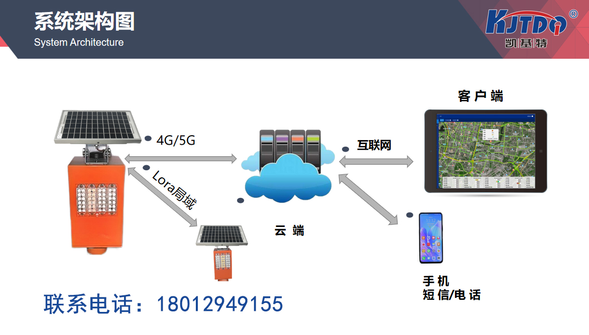
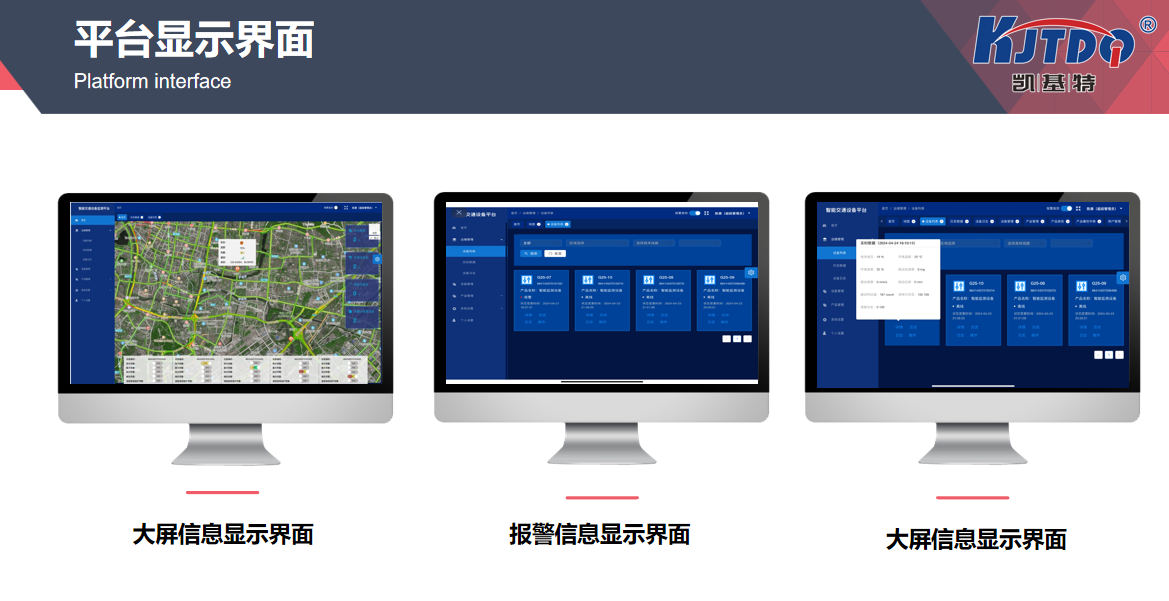
The core of the landslide monitoring system for highway sections lies in real-time monitoring and data analysis. This system is usually equipped with various high-tech sensors and monitoring devices, which can real-time collect key indicators such as geological structure, rainfall, soil moisture, etc. of the road section. For example, geological sensors can monitor small changes in soil, rainfall meters record precipitation, and soil moisture sensors focus on the moisture level of the soil. These data are collected and transmitted to the central processing system. Through analysis and processing, the system can promptly detect potential landslide risks and issue warning signals.
The introduction of intelligent technology has made the landslide monitoring system on high-speed roads more efficient. The modern landslide monitoring system not only relies on traditional sensors, but also combines advanced means such as drones and remote sensing technology. Drones can conduct aerial patrols in high-risk areas, obtaining high-definition images and video data that can help experts detect geological changes or signs of landslides in a timely manner. In addition, remote sensing technology obtains a wider range of geological information through satellite images, which helps to assess and warn of large-scale landslide risks.
The application of artificial intelligence (AI) technology in landslide monitoring cannot be ignored. AI can identify potential patterns and trends of landslides through learning and analyzing large amounts of historical data. The system can use machine learning algorithms to compare real-time monitoring data with historical data and predict potential landslide risks. For example, when the AI system detects abnormal soil moisture and rainfall, it can quickly make judgments and issue warnings. This data-driven warning mechanism not only improves the accuracy of monitoring, but also enhances the response speed of the system.
However, despite the important role played by landslide monitoring systems on high-speed roads in improving road safety, there are still some challenges in practical applications. Firstly, the maintenance and upgrading of equipment require continuous investment, especially in remote areas or with limited funds, which may become obstacles to promoting applications. Secondly, the accuracy and reliability of the system need to be continuously verified and optimized to ensure the effectiveness of warning information. In addition, the implementation of landslide monitoring systems also requires effective emergency plans and response measures to ensure that prompt action can be taken after warnings occur and prevent landslide accidents from happening.

From a personal perspective, the landslide monitoring system for highway sections is undoubtedly an important advancement in modern traffic safety management. It provides a solid guarantee for road safety through real-time monitoring and intelligent analysis. However, while technology is important, the safety awareness of drivers is equally crucial. While enjoying the safety guarantee brought by landslide monitoring systems, each of us should also pay more attention to road conditions, abide by traffic rules, maintain safe driving speeds, and minimize the impact of landslides on travel safety.
In short, the landslide monitoring system for highway sections is an important technical means to improve road safety. Through real-time monitoring and intelligent analysis, it can effectively prevent landslide accidents and ensure the smooth and safe operation of highways. With the continuous advancement of technology, we have reason to believe that these systems will become more precise and efficient, providing stronger protection for our travel. At the same time, we must also maintain our attention to road safety, be proactive, and ensure that every driving experience is smooth and safe.
1. How to combine different monitoring technologies to improve the overall efficiency of landslide monitoring systems on highway sections?
The landslide monitoring system for highway sections improves overall efficiency through the comprehensive application of various monitoring technologies. Different monitoring technologies can complement each other and provide more comprehensive and accurate data:
1. Geological sensors and remote sensing technology: Geological sensors can provide detailed soil displacement and pressure data, while remote sensing technology obtains a larger range of geological information through satellite images. This combination can simultaneously monitor landslide risks at both local and macro levels.
2. Drones and ground sensors: Drones provide high-resolution aerial images and videos to help detect hard to reach areas, while ground sensors monitor key parameters such as soil moisture and rainfall in real-time. The data from drones can be combined with data from ground sensors to form a more accurate risk assessment.
3. AI analysis and traditional data: Artificial intelligence (AI) technology can analyze historical and real-time monitoring data to identify potential landslide patterns, while traditional data collection methods ensure the basic accuracy of the data. The predictive ability of AI combined with the actual monitoring of traditional methods can provide more reliable warning information.
Through the integration of these technologies, the system can gain a more comprehensive understanding of changes in the geological environment, predict landslide risks more accurately, and improve the overall monitoring effectiveness.
2. How does the landslide monitoring system handle and respond to the impact of various weather conditions on monitoring data?
The impact of weather conditions on landslide monitoring data is an important issue, so monitoring systems usually have some countermeasures:
Waterproof and dustproof equipment: Monitoring sensors and devices are usually designed to be waterproof and dustproof to reduce the impact of adverse weather conditions on the equipment. For example, the sensor housing may be made of waterproof materials and sealed in important areas to ensure the normal operation of the equipment in rainy and snowy weather.
Data correction algorithm: The system will use data correction algorithms to handle abnormal data caused by weather conditions. For example, during heavy rainfall, the system will adjust real-time data based on historical rainfall data and model predictions to eliminate data errors caused by rainfall.
Multi point monitoring: Deploying multiple monitoring points in landslide risk areas can provide diverse data perspectives and reduce the bias of a single sensor affected by weather. By integrating data from different points, the system can more accurately assess the overall situation.
These measures help ensure that the landslide monitoring system can maintain efficient operation and provide reliable monitoring data even under adverse weather conditions.
3. How to conduct a cost-benefit analysis of deploying landslide monitoring systems on highways?
The cost-benefit analysis of deploying a landslide monitoring system on highways involves multiple aspects:
Equipment cost: including the construction and maintenance costs of sensors, drones, and monitoring centers. Although the initial investment is relatively high, in the long run, these devices can reduce the economic losses caused by landslide accidents, especially in severe landslide events, which can save a large amount of property and lives.
Maintenance cost: The system requires regular maintenance and calibration to ensure its accuracy and reliability. The maintenance cost includes equipment inspection, repair, and technical support. Investing in high-quality equipment and establishing a comprehensive maintenance system can reduce long-term maintenance costs.
The cost of accident prevention and reduction: Landslide monitoring systems can prevent landslide accidents, reduce traffic interruptions, accident damage, and rescue costs caused by landslides. Through real-time warning of the system, the impact of landslide accidents can be avoided or reduced, thereby saving huge social costs and human resources.
By comprehensively considering equipment costs, maintenance expenses, and accident prevention effectiveness, the overall economic benefits of landslide monitoring systems can be evaluated. Although the initial investment is relatively high, long-term cost savings and security guarantees can significantly improve the system's return on investment.