The highway collapse warning system, as an important component of modern traffic safety management, is gradually becoming a key tool for protecting road smoothness and driving safety. In recent years, with the frequent occurrence of climate change and natural disasters, the risk of road collapse incidents has become increasingly high. This not only brings difficulties to transportation, but also threatens the life safety of every road user. Therefore, the role of the highway collapse warning system is becoming increasingly prominent. It can provide important information support for road management through real-time monitoring and warning, timely prevent and respond to collapse accidents, and ensure everyone's safe travel.

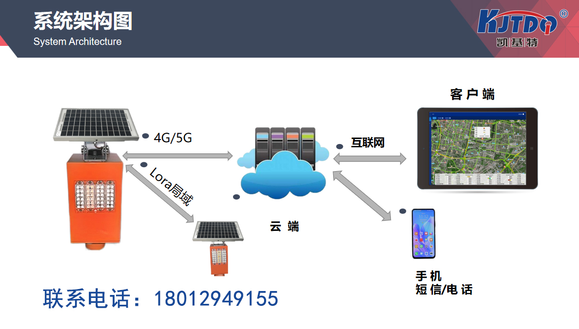
The highway collapse warning system monitors the road and its surrounding environment in real-time to identify various risk factors that may lead to landslides. These risk factors include geological conditions, rainfall, soil moisture, etc. The system collects a large amount of data and conducts real-time analysis through sensors and monitoring devices installed in critical locations. If the system detects abnormal changes in the geological structure of a certain area or rainfall exceeding the preset threshold, it will automatically issue a warning, notify the traffic management department and relevant personnel, and take countermeasures in advance. This real-time warning mechanism can greatly reduce the probability of landslides and minimize the losses caused by accidents.
The modern highway collapse warning system not only relies on traditional monitoring methods, but also introduces many advanced technologies. For example, using drones to take high-definition photos and analyze mountains and roads can more accurately obtain geological information and timely detect potential risk points. The application of drones makes monitoring work more efficient and accurate, enabling rapid acquisition of data in difficult to access areas and improving the overall effectiveness of early warning systems.
In addition, the highway collapse warning system also utilizes big data analysis and artificial intelligence technology. By deeply mining and analyzing historical data, the system can identify different types of landslide patterns and trends and make predictions. For example, the system can predict the risk of landslides during a specific period by analyzing historical rainfall data and geological changes, in order to take preventive measures in advance. This predictive function based on data analysis enables early warning systems to assess risks more scientifically and accurately, improving their prevention capabilities.
In practical applications, the construction of a highway collapse warning system requires comprehensive consideration of various factors, including equipment selection, data processing, and the design of warning mechanisms. Firstly, the selection of equipment should be based on the actual geological environment and monitoring requirements to ensure the accuracy and stability of sensors and monitoring equipment. Secondly, data processing and analysis require advanced technology platforms and real-time algorithm optimization to improve the timeliness and accuracy of early warning. Finally, the design of the warning mechanism needs to fully consider the response strategies for different situations, ensuring that effective measures can be taken quickly in the event of a warning.
Although the highway collapse warning system has played an important role in improving road safety, it also faces some challenges in practical operation. For example, the maintenance and upgrade of the system require a certain amount of funding and technical resources, which may become obstacles to promotion and application in some economically underdeveloped areas. In addition, the accuracy and reliability of the system also need to be continuously optimized and verified to ensure the effectiveness of warning information.
From a personal perspective, the highway collapse warning system is undoubtedly an important tool for ensuring road safety. It not only improves the response capability to natural disasters, but also provides scientific decision-making basis for transportation management departments. However, we cannot rely solely on these high-tech devices and systems. While using the highway landslide warning system, drivers and road managers should also maintain a high level of attention to weather changes and road conditions, comply with traffic rules, drive cautiously, and minimize the impact of landslides on traffic safety.

Overall, the highway collapse warning system is an important technology in modern traffic safety management. Through real-time monitoring and prediction, it can detect and prevent collapse risks in advance, providing a solid guarantee for road safety. With the continuous advancement of technology and the deepening of its applications, we have reason to believe that these systems will become more intelligent and precise, providing us with better protection for our travels. At the same time, we should also maintain vigilance and self-management towards road safety while enjoying the convenience brought by these technologies, ensuring that every trip is safe and smooth.
1. How does the highway collapse warning system monitor and prevent collapse risks in real time?
The highway collapse warning system monitors the road and its surrounding environment in real-time through various sensors and monitoring devices. The system typically includes geological sensors, rain gauges, soil moisture sensors, etc. These devices are capable of continuously collecting data on geological structures, weather conditions, and soil conditions. For example, geological sensors can detect soil displacement and pressure changes, rainfall meters record changes in precipitation, and soil moisture sensors monitor soil moisture. These data are transmitted in real-time to the central processing system, and through data analysis and model prediction, the system can identify potential landslide risks. When the monitored parameters exceed the preset threshold, the system will automatically issue a warning notification to remind the traffic management department and relevant personnel to take measures, such as closing dangerous areas, adjusting traffic routes, or reinforcing them. This real-time monitoring and warning mechanism can greatly reduce the probability of landslide accidents and improve road safety.
2. What is the role of drones in road collapse warning?
Drones are playing an increasingly important role in road collapse warning. Drones are equipped with high-resolution cameras and sensors, which can comprehensively and detailedly capture and monitor mountains and roads. Its main functions include:
1. Efficient data collection: Drones can quickly cover a wide area and obtain high-definition image and video data. These data help experts identify cracks, signs of landslides, and other potential landslide risks in the mountain.
2. Monitoring of difficult to access areas: Some hazardous areas are difficult to inspect through traditional means, such as cliff edges or unstable mountains. Drones can safely enter these areas for inspection, thereby improving the comprehensiveness and accuracy of monitoring.
3. Real time data transmission: Drones can transmit the captured data to the monitoring center in real time, allowing relevant personnel to quickly obtain the latest geological information and make timely decisions.
4. Post disaster assessment: After a landslide accident occurs, drones can quickly conduct aerial surveys of the disaster area, assess the scale and impact of the landslide, and provide detailed image data for rescue work.
3. What challenges does the highway collapse warning system face in practical application?
The highway collapse warning system faces some challenges in practical application, including:
1. Data collection and processing: The collection of monitoring data requires high-precision equipment and sensors, and the maintenance and upgrading of these devices may require high costs. In addition, data processing and analysis also require strong computing power and technical support.
2. Environmental impact: The sensors and monitoring equipment of the system may be affected by weather conditions, environmental pollution, and other factors, which may lead to inaccurate data collection or system failures.
3. Technical complexity: The integration and maintenance of high-tech equipment and systems require professional technical personnel, which may be a major challenge for some resource limited areas.
4. Implementation of warning mechanism: Even if the system can accurately issue warnings, how to effectively implement warning measures and coordinate resources from all parties is still a problem that needs to be solved. For example, how to quickly close the dangerous area after warning and how to notify the driver in a timely manner are all aspects that need to be fully considered.
4. How can the application of big data analysis and artificial intelligence improve the accuracy of highway collapse warning?
Big data analysis and artificial intelligence (AI) technology can significantly improve the accuracy and timeliness of highway collapse warning. Specific applications include:
1. Data mining and trend analysis: By analyzing a large amount of historical data, AI systems can identify potential patterns and trends of landslides. This includes analyzing historical data on factors such as rainfall, geological changes, and soil moisture to predict potential future collapse events.
2. Pattern recognition: AI technology can identify small anomalies in geological changes through machine learning algorithms, which may indicate impending landslides. For example, AI can analyze small displacements and pressure changes in soil and issue timely alerts.
3. Real time warning: By combining real-time and historical data, AI systems can more accurately assess the current risk of landslides. The system can compare real-time monitoring data with historical data, quickly make risk assessments, and issue warnings.
4. Optimize warning strategies: AI can also optimize warning strategies based on different risk factors and conditions. For example, under certain weather conditions, the system can automatically adjust the threshold and strategy of warnings to improve their accuracy and reliability.